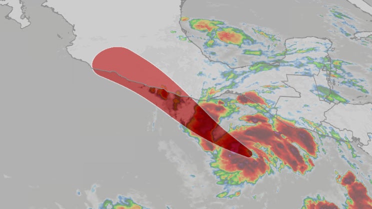
What Happened
Tropical Storm Erick formed in the Eastern Pacific Ocean and is expected to rapidly intensify into a hurricane as it approaches the southwestern coast of Mexico. The storm was identified approximately 450 miles southeast of Punta Maldonado, Mexico, and is the fifth named storm of the 2025 Eastern Pacific hurricane season. Forecasts indicate that Erick could reach hurricane strength by Wednesday, with warnings and watches already issued for parts of Mexico’s Pacific coast, particularly in the states of Oaxaca and Guerrero. The storm is anticipated to make landfall on Thursday, bringing with it heavy rainfall and strong winds.
As Erick approaches, meteorologists have noted that warm ocean waters and favorable atmospheric conditions are likely to contribute to its intensification. The National Hurricane Center (NHC) has projected that Erick could reach at least a Category 2 hurricane status by the time it nears the coast, with some forecasts suggesting it could be even stronger. The storm’s path is expected to bring significant rainfall, with estimates of 8 to 16 inches in some areas, potentially leading to life-threatening flash flooding and mudslides.
Key Details
- Formation and Location: Tropical Storm Erick formed early Tuesday morning, about 450 miles southeast of Punta Maldonado, Mexico.
- Forecasted Intensity: The storm is expected to become a hurricane by Wednesday, with the NHC predicting it could reach at least Category 2 status.
- Warnings Issued: Hurricane warnings and watches are in effect for the southwest coast of Mexico, extending to the Acapulco area.
- Projected Rainfall: Heavy rainfall is forecasted, with totals ranging from 8 to 16 inches, and localized amounts up to 20 inches possible, particularly in mountainous regions.
- Landfall Timing: Peak impacts are expected on Thursday, with heavy rain and strong winds beginning to affect Oaxaca and eastern Guerrero states by late Wednesday.
Multiple Perspectives
Meteorologists emphasize the unpredictability of the storm’s exact landfall location due to its parallel track relative to the coastline. This uncertainty complicates the assessment of where the most severe impacts will occur, particularly regarding storm surge and wind damage. Some experts argue that the potential for rapid intensification necessitates close monitoring, as even slight changes in the storm’s path could lead to significantly different outcomes for affected regions.
Local authorities in Mexico are preparing for the storm’s arrival, with emergency services on alert for potential flooding and mudslides. Residents in vulnerable areas are being urged to take precautions and prepare for possible evacuations. Meanwhile, some commentators have noted the early formation of Erick, occurring more than a month ahead of the historical average for the fifth named storm, suggesting a potentially active hurricane season ahead.
Context & Background
The Eastern Pacific hurricane season typically runs from May 15 to November 30, with the fifth named storm historically forming by July 23, based on averages from 1991 to 2020. The early formation of storms like Erick may indicate changing climatic patterns, which have been linked to warmer ocean temperatures and other environmental factors. Understanding these trends is crucial for disaster preparedness and response, particularly in regions like Mexico that are frequently impacted by tropical storms and hurricanes.
The potential impacts of Erick are particularly concerning given the recent history of severe weather events in the region. Local governments and emergency services are likely to be on high alert, recalling past storms that have caused significant damage and loss of life.
What We Don’t Know Yet
As of now, uncertainties remain regarding the exact trajectory and intensity of Tropical Storm Erick as it approaches Mexico. While forecasts suggest it could become a strong hurricane, changes in atmospheric conditions could alter its path and strength. Additionally, the extent of rainfall and the potential for flooding and mudslides in specific areas are still being assessed, as localized weather patterns can significantly influence these outcomes.
The situation is evolving, and further updates from meteorological agencies will be crucial in providing more accurate predictions and guidance for residents in the storm’s projected path. Emergency preparedness measures are being implemented, but the effectiveness of these responses will depend on the storm’s behavior in the coming days.